Kaçmaz Arsa — Interactive Land Map
Parcels, zoning overlays and surrounding amenities for a Turkish land-investment firm — rendered to feel less like a GIS export and more like a brochure.
Open the live mapCartography · GIS · Design
I'm Ana Clara Santos — a forest engineer and designer working between cartography, GIS and the web. I help mission-driven projects in conservation, science and small business turn complex territory into clear stories.
Based in Acre, Brazil — the triple frontier of Brazil, Peru & Bolivia.

About
I trained as a forest engineer at the Universidade Federal do Acre, and my undergraduate research traced thirty-seven years of land-use change inside the Chico Mendes Extractive Reserve — using MapBiomas data and Google Earth Engine to ask how policy, settlement and illegal deforestation reshape the western Amazon.
Since 2021 I've worked across three worlds: as a research assistant at Cornell University on aspirational well-being for Amazonian youth; as a technical assistant at CPI-Acre, supporting indigenous territorial monitoring on the Nawa, Nukini and Cabeceira do Rio Acre lands; and as the founder of ACS Consultorias, which has reached more than 400 people through geotechnology training and environmental regularization in the Amazon.
I design websites for the same kinds of clients — clean, calm, content-first sites for consultancies and conservation projects who deserve better than a template.
Cartography & Spatial Analysis
A small portfolio of recent work — interactive web maps and printed atlases.
Parcels, zoning overlays and surrounding amenities for a Turkish land-investment firm — rendered to feel less like a GIS export and more like a brochure.
Open the live map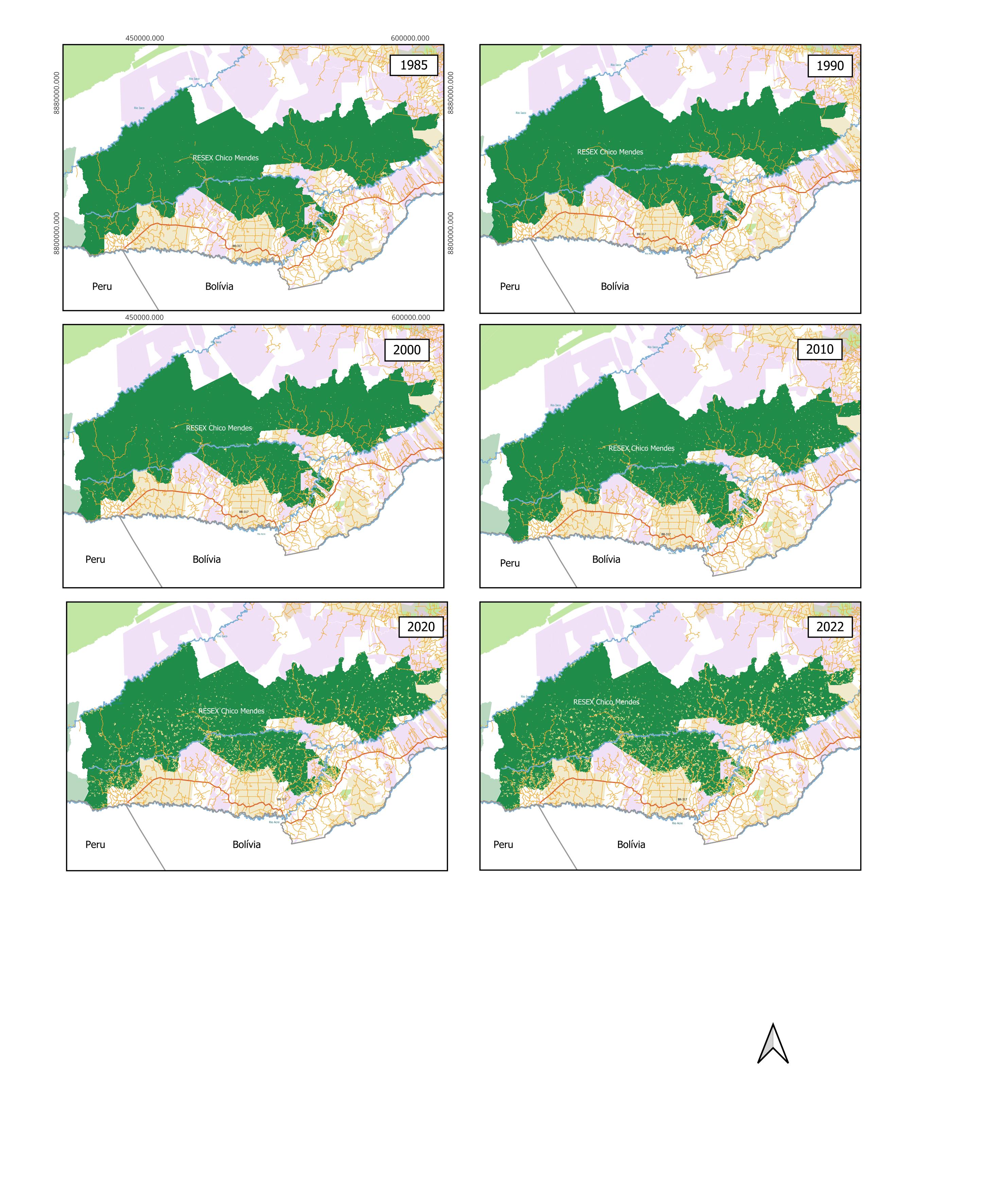
Thirty-seven years of land use and land cover, frame by frame. Built from MapBiomas Collection 8 and Google Earth Engine for my undergraduate monograph.
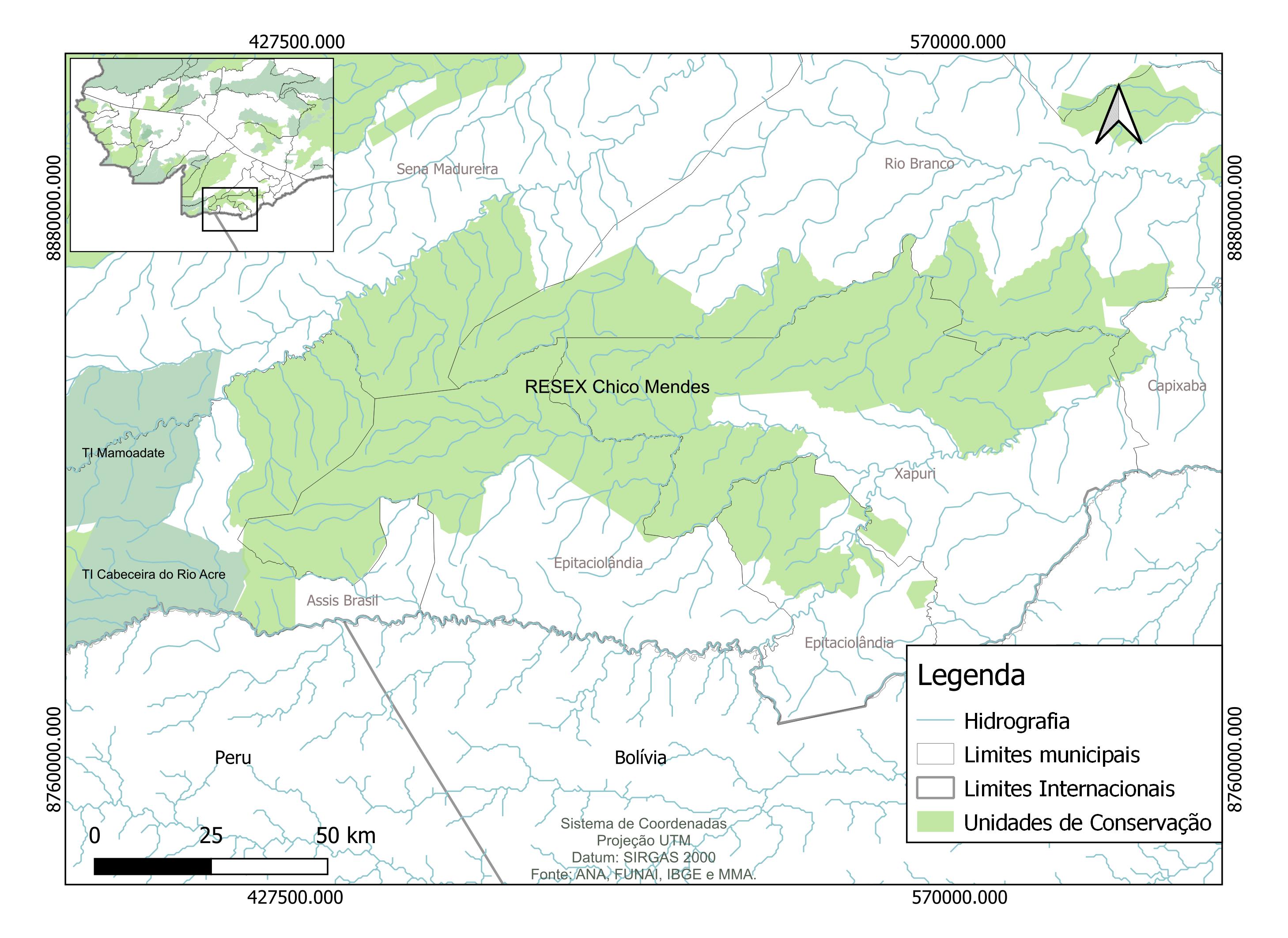
Hydrography, conservation units and the Brazil–Peru–Bolivia triple frontier. Sources: ANA, FUNAI, IBGE, MMA. SIRGAS 2000 / UTM.
Design for the web
Lead designer & developer · 2025
Editorial-style site for a London-based engineering consultancy.
Lead designer & developer · 2025
A bilingual property-investment site with embedded interactive map.
Collaborator · 2024
Contributing designer on a German solar-energy company's bilingual presence.
Currently accepting partners
Envreg is a service for environmental regularization in rural Brazil — built on the same fieldwork, GIS pipelines and community engagement my team has used since 2021. The platform is in active development, and I'm currently inviting partners: regional agronomists, environmental lawyers, fintech operators and investors who care about the Amazon.
My B2B and B2C consultancy supporting rural producers, indigenous communities and conservation projects across the Amazon since 2021.
acsconsultorias.com.brContact
Project enquiries, partnership ideas, or just to say hello. I read every message and reply within two working days.
anaclara@forestana.com